
The October 1804 edition of the Gentleman's Magazine - edited by Edward Cave under his pen name of Sylvanus Urban - carried an article on Gibraltar written by the anonymous correspondent, 'Nauticus'. The author was referring to a visit to Gibraltar that took place from January 1801 to April 1802.
Gibraltar - Being at anchor lately in the bay of Gibraltar, that wonderful place could not fail of exciting my curiosity lo go ashore and examine more particularly the place. If the small account here subjoined should he worth preserving it is at your service. Nauticus
The Rock is most wondrously situated; its shape very much resembles a barn . . . the North end is highest being one mile and half. . . .
.jpg)
The wharf and the Devil's Tongue ( 1804 - Henry Aston Barker )
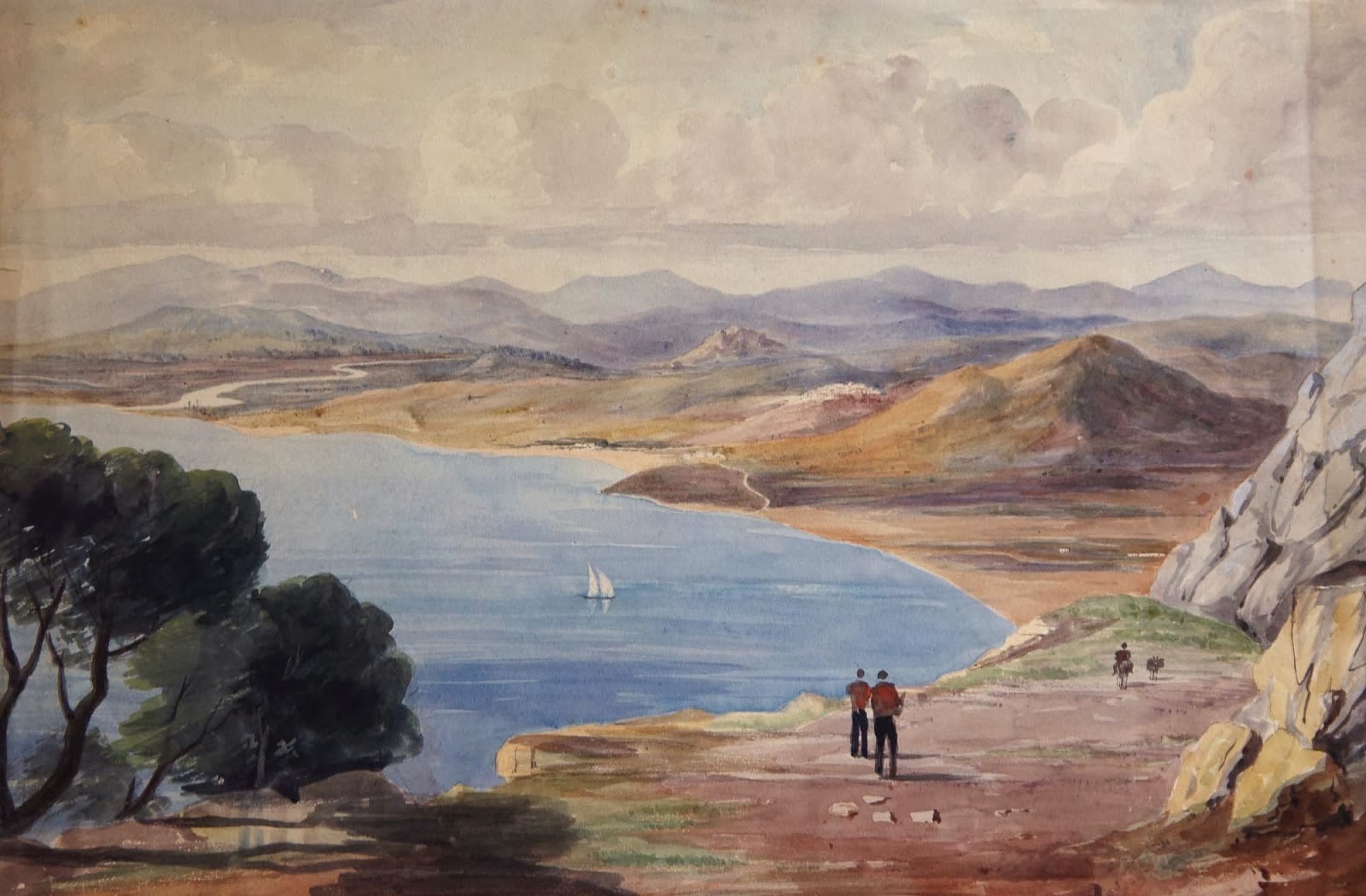
The author then continues to describe the geography in general terms mentioning many of the nearby Spanish and African towns and places such as Malaga, Estepona, Granada, Cabrita Point, Algeciras, the Queen of Spain's Chair, Ceuta, Ape's Hill and Tangier all of which were visible from Gibraltar. I am not quite sure I would agree that the shape of the Rock resembles a barn and I would definitely argue against the North end being the highest point or indeed reaching anywhere close to a mile and a half in height.
Catalan Bay . . . . On the east side, at the bottom of the Rock, which is nearly perpendicular and very cragged, is Cataline bay: here is but one house; there are several caves or holes in the Rock where the fishermen live; there is a garden belonging to the house. where the owner sells wine, porter, fish, etc. to those who go about the Rock examining its parts.

About half a century later the number of houses at Catalan Bay had increased substantially. Nevertheless the artist who created this picture also managed to get the name wrong - he called it Catland Bay ( 1861 - Henry Stratton Bush )
The lower part of this side is sand; on the higher part grows a plant of which brooms are made; here are a few guns on this side. Between the house and the Europa point, high up in the Rock, is a cave. at the entrance of which are three stones, so much in the shape of men dressed in the Turkish habit, that l as well as most other travellers took them to be such, to the great amusement of my guide, who for that purpose asked me if I did not see three men sitting at the cave's mouth.
Great part of this side Northward is sandy, at the bottom are also found muscles ( sic) in plenty. On the West side, at the bottom, is the town of Gibraltar, a very populous place, being some few of most nations, but chiefly English and Spanish; these two last are the languages chiefly spoken.
Northward is sandy ( 1833 - Frederick Leeds Edridge )
St Michael's Cave - On this side, higher up, nearer Europa Point, is a very large cave, called St. Michael's, the entrance is so very steep that it is descended with some difficulty; from this place are several avenues, or a great many windings and narrow places, of which no one has ever found the end, though attempted by many.
Some believe they go under the Mediterranean Sea Eastward, but one or two go different ways; it is said one goes through the Rock to the town, another finds its way out a little distance from the entrance : the water keeps dripping through the top, and form several curious petrifactions, and some pillars are formed of a great thickness, some hang like icicles; there are a great number of loose stones in the bottom.

St Michaels Cave (1796 - Rev Cooper Willyams )
The Moorish Castle - On this side near the North is a large old castle, called the Moorish Castle, being built by them when in their possession: it is all brick, but so thick that it has resisted a great number of shot, which may plainly be seen by its sides: a continuation of the building to the seaside is formed by a kind of wall.

The Moorish Castle - at the time of writing, those 'thick' walls are still pock-marked with shot to this day ( 1830s - William Mein Smith )
Between this and the North-east are several caves cut through the Rock, out of which are pointed a number of guns in nearly all directions but most command the land side, or Neutral ground. Each has its name, as St. George's Cave, Lord Cornwallis's cave: the latter is very spacious. The magazines are all in the Rock. To these places a soldier attends the company.
These 'caves' were in fact Gibraltar's well known Galleries hacked out of the Rock by Sergeant Ince and his artificers during the Great Siege. ( see LINK ) The place was understandably out of bounds to civilians - other than with some sort of a permit and accompanied by a soldier.
. . . There are some buildings for the guns at North-end; they point mostly to the Spanish lines and batteries of which there are two; one battery North-east commands the bay, the other on the West-coast near the Mediterranean sea . . . . at the North end part of the Rock is blown up for building.
The Spanish lines were destroyed by the British in 1810 during the Peninsular wars, albeit with the reluctant consent of the Spaniards The batteries were actually fully fledged fortresses. The one on the east coast of the isthmus was called San Felipe, the one on the east, Santa Barbara.
.jpg)
Map of the isthmus with the North front of the Rock on the right and the Spanish lines on the left. The fprtress at the top is Santa Barbara, the one at the bottom of the map is San Felipe ( 1779 - Sayer and Bennet - detail )
Signal Tower . . . The signal tower informs the town and the ships in the bay what ships are coming East or West and of what nation. Under the signal tower are two guns, one of which fires every night at sunset, and eight o'clock in winter, nine in summer, and daybreak every morning, called the sun-set gun.
Difficult to make out why the need for two guns and whether one was used at night and the other at day-break.
Windmill-hill and Red Sands - At Windmill-hill is a signal tower, but never used: sentinels are constantly at all these places. From Windmill-hill in the descent to Europa Point is a large stone handsomely cut in the Rock . . . in this part is a red kind of earth, of which a few bricks are made. . . . . here is also a stone of a slate colour from which diamonds are extracted but are so very small as not to be worth the labour of breaking and searching for them.
The tower may have been the old Torre de los Genoveses which now no longer exists - or perhaps some other old Spanish structure similar to la Torre del Diablo on the isthmus - also long gone. The failure to mention wind-mills as such suggests there were none there at the time. I cannot place the large handsomely cut stone and the use of the red sand to produce bricks and the mention of diamonds are not often mentioned in the literature.

The North face of the Rock showing the gallery embrasures and the isthmus with fever houses ( 1800s - Unknown )
The Town - The West side is not a regular slope; in one place it is so steep that a large piece of rock is broke off, but is secured by a kind of iron dogs to keep it from rolling down upon the houses below. On the West side are two moles, one near the North end and the other the South. Also a convenient dock-yard and a place where boats land, called the Ragged Staff.
The Lazaretto is also at the north end where are also most of the small craft and merchants. Here is generally a kind of market held of fowls, pieces of raw sugar-cane etc. To enter the town at this end you must pass a sally-port. . . . the hospital, which has an elegant appearance, and the Barracks, are nearer Europa Point; also the burying ground; but the church, (the only English one in this place) is adjoining to the Governor's house . . .
The Lazaretto . . . a premonition of things to come? It was in 1804, the year in which this article was published one thousand people from the Garrison and about five times that many from the civilian population would be dead from yellow fever before the end of the year. ( see LINK ) The Lazaretto would increase in size - and activity - for several decades to come. ( see LINK ) The sally-port may have been Waterport Gate leading from the wharf into the market area just in front of the Casemates.

1844 - The Wharf and the Spanish Lines ( 1844 - George Lothian Hall )
The Spanish Church - The Spanish church is not far distant; in it are images of the Virgin Mary, and several others in wax-work, dressed in black silk; and over the altar stands a large figure of Joseph of Arimathea, at which all bow after returning from the altar; there are also a great many very beautiful paintings.
Here are a number of Spaniards, whose customs and manners differ from the English, in wearing cloaks, or some great coats, with only the left arm in the sleeve, the other thrown over the shoulder, and seldom go out but with a cigar or pipe in their mouths, but the former is chiefly preferred.

A Spaniard ( 1833 - David Roberts )
There is also a sect which dress different to the others; their heads are shaved, and beards grow, wear a kind of cap, a shirt and scarce any collar, white waistcoat, buttons down the middle, over that a red one, and outmost a short black kind of gown or coat, so contrived that all are seen, the red one buttoning but half way, and the outer one scarce at all.
This extraordinarily precise description of local dress may refer to a kind of uniform adopted by the Jewish porters. Generally a very non-committal and uncritical description of the place - which was very unusual for early 19th century visitors.
A Jew of Gibraltar ( 1840 - Unknown )
